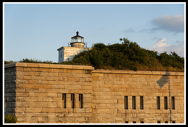
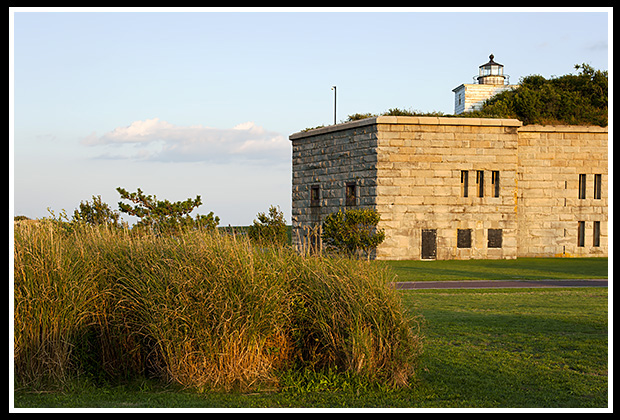
Clark's Point Lighthouse
New Bedford, Massachusetts
Built in 1804
Location:
The lighthouse sits atop Fort Taber (Rodman) at the entrance to New Bedford Harbor.
Latitude: 41° 35' 32" N
Longitude: 70° 54' 02" W
Historic Stories:
Clark’s Point became a main defense station for New Bedford after the British landed and burned New Bedford in 1778 during the Revolutionary War. It also became a key site for defense during the War of 1812, and the Civil War, occupied by the citizens nearby for defense. It did not receive major artillery pieces until during the Civil War through efforts by Mayor Issac Taber of New Bedford in which the fort was named after honoring his efforts.
One of the keepers of the lighthouse was Henry M. Smith, a renowned wood carver who created elaborate figureheads for New Bedford ships.
|
Smith used some of his woodworking skills to help complete a needed keeper’s dwelling in 1842. |
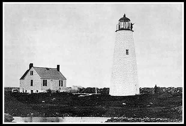
Early Clark's Point Light |
During the 1850s, when slaves were escaping from the tyranny of their southern masters, a vessel that delivered supplies to New England lighthouses secretly transported a Negro slave woman and her two children, a boy and girl, to the Clark’s Point Lighthouse. The trio were sneaked into town from the lighthouse under the cover of darkness and provided with safe haven in New Bedford. The boy, Charlie, grew up there and became a well-known livery driver, transporting locals to their destinations.
Clark’s Point became a main defense station for New Bedford, after the British landed and burned New Bedford in 1778 during the Revolutionary War. It also became a key site for defense during the War of 1812, and the Civil War, occupied by the citizens nearby for defense. The fort did not receive major artillery pieces until during the Civil War, through efforts by Mayor Issac Taber of New Bedford, whom the structure was named after to honor his efforts. No shots were ever fired from the fort.
Eventually, the cost of sperm whale oil, and the longer length of time for ships to hunt whales increased, making kerosene as the main source for lighting lanterns. With the local whaling industry decreasing, the fort at Clark’s Point was deemed as unnecessary.
On April 30, 1898, Clark’s Point Light was decommissioned after the lighting of Butler Flats Lighthouse and then after much restoration of the fort and the park, relit in 2001.
Places to Visit Nearby:
New Bedford’s history involves its rising status as one of the world’s main whaling ports.
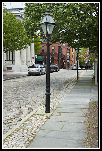 |
The city is still a busy fishing port, and nearby you’ll find you’ll find the New Bedford Whaling National Historic Park with its cobblestone streets, specialty shops, and museums. |
New Bedford’s Whaling Museum displays maritime exhibits and historical artifacts from its hay day in the 19th century, as the nation’s whaling capital. Rotch-Jones-Duff Garden Museum showcases three elegant homes from merchants of the whaling area, with a full city block of special gardens. Other museums include the New Bedford Fire Museum to see fire trucks from the 1800s, and the New Bedford Museum of Glass for exploring the elegance of glass from around the world. The Buttonwood Park and Zoo in New Bedford is a convenient small zoo with over 200 species of animals.
For those who enjoy hiking, take a good hike that spans over 9,000 feet on the largest hurricane barrier on the East Coast, protecting New Bedford Harbor. At the beginning you're very close to Clark's Point Lighthouse, where you can also view Butler Flats light from the wall.
| Hiking over the largest hurricane barrier to the inner harbor area, you’ll find close views of Palmer Island Light. | 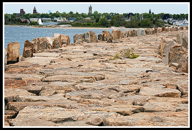 |
Be wary to travel during the daytime with companions.
Moved in 2015 to Boothbay Harbor in Maine for a complete restoration, and returned in 2018, you can visit the restored 156-foot Schooner Ernestina built in 1864, which is the official vessel of the Commonwealth of Massachusetts located in New Bedford on the State Pier. Its legacy includes sailing to within 600 miles of the North Pole, and providing safe sailing for immigrants.
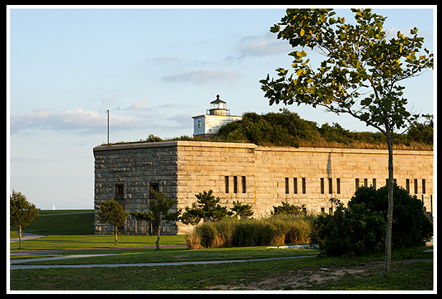
Historic Fort Taber in New Bedford (or sometimes referred as Fort Rodham) has been restored as a recreational park.
| Here visitors can enjoy views of the harbor, Clark’s Point Lighthouse within the fort, and Butler Flats Lighthouse out in the river. | 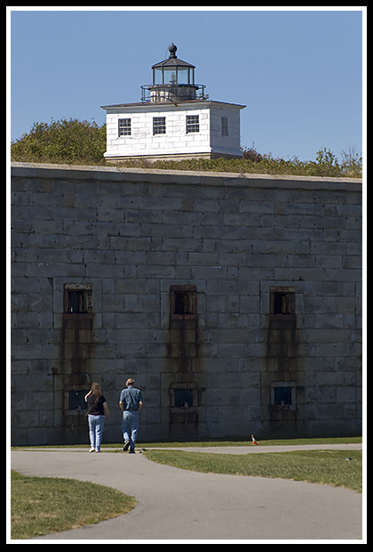 |
A lighted boardwalk has also been added for visitors to relax, or fish off shore. Events are scheduled during the summer months. Note: The name of the new park is Fort Taber Park on recent maps, and older maps use Fort Rodman Military Reservation to label the fort at Clark’s Point.
Clark’s Point Lighthouse is located on top of the Fort. Seastreak to Martha’s Vineyard from New Bedford passes by the lighthouse. The Cuttyhunk Ferry passes the lighthouse as it leaves the harbor.
If you always wanted to dive and explore some of New England's shipwrecks, among other services, visit Quest Marine Services, in Fairhaven across the river.
On the other side of the Acushnet River, across from the hurricane wall into Fairhaven, the Fort Phoenix State Reservation has a half-mile of beachfront where visitors can look out and enjoy the views. For history buffs, this is where the first naval battle of the Revolutionary War was fought.
Directions:
- Take Route 18 south in New Bedford.
- Route 18 will turn into Water Street and then West Rodney French Boulevard.
- Continue south and you will see Fort Taber Park, with the fort and the lighthouse at the southern end of the peninsula.
Alternate Directions from US Route I-95 North:
- From US Route I-95 North in New Bedford, take Exit 15 and follow Route 18 South.
- Take the “Downtown” exit onto Water Street.
- Take a left at Union Street (one way) and cross over Route 1 (Kennedy Highway)
- Take a right at Frontage Road (Front Street).
- From Frontage as it veers to the right, go past the pier and follow to MacArthur Drive then turn left.
- Take Right at Potomska Street
- Left at Front Street
- Cross Gifford Street into Norton Court
- Left at Cove Road onto East Rodney French Blvd.
- View the lighthouse from the seawall south of Ricketson Street or from Fort Taber Park, which you can visit.
Contact Info:
City of New Bedford
133 William Street
New Bedford, MA 02740
Local Boat Ferries
These ferries may pass close by the lighthouse coming to and from New Bedford's Harbor for easy photographs, but do not offer specific tours.
Cuttyhunk Ferry Company, Inc.
66B State Pier, South Bulkhead
New Bedford, MA 02740
(508) 992-0200
Seastreak
Ferry from New Bedford to Martha’s Vineyard
49 State Pier
New Bedford, MA 02740
(866) 683 3779
Books to Explore
To order a signed paperback copy: Available from bookstores in paperback, hardcover, and as an eBook for all devices.
|
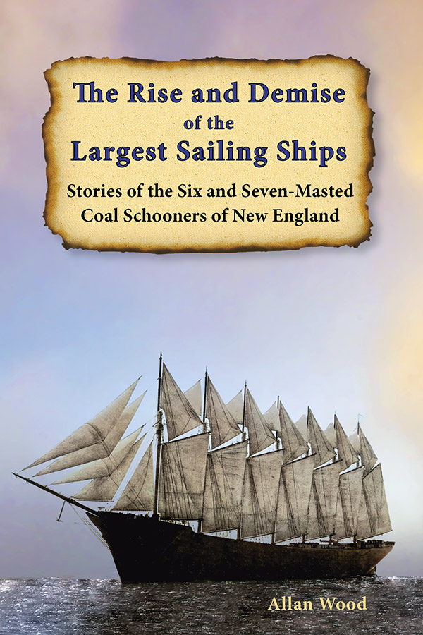
The Rise and Demise of the Largest Sailing Ships: In the early 1900s, New England shipbuilders constructed the world’s largest sailing ships amid social and political reforms. These giants of sail were the ten original six-masted coal schooners and one colossal seven-masted vessel, built to carry massive quantities of coal and building supplies, and measured longer than a football field! This book, balanced with plenty of color and vintage images, showcases the historical accounts that followed these mighty ships. These true stories include competitions, battling destructive storms, acts of heroism, and their final voyages. |
Check out my book, Lighthouses and Coastal Attractions of Southern New England: Connecticut, Rhode Island, and Massachusetts, provides special human interest and historical stories from each of the 92 lighthouses, along with plenty of indoor and outdoor coastal attractions and tours you can explore. Look inside! |
|