
Driving and Hiking Directions to
Massachusetts Lighthouses
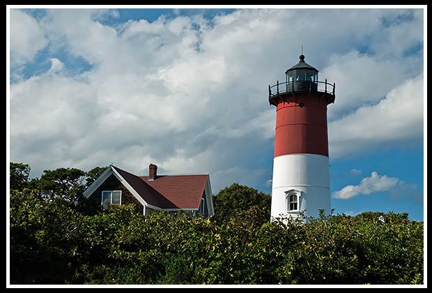
Nauset Lighthouse
Lighthouse Driving Directions Quick Guide
Heading Northeast
Of the 55 lighthouse locations in Massachusetts , there are many where visitors can drive, hike, or take a ferry to explore. Links are provided to each lighthouse page where you can find lots of historic stories on that lighthouse, and places to visit near the light. Martha's Vineyard and Nantucket Island lighthouses are included as you will need a ferry to access, which information is provided here, and once on the island you can hike, bike, or drive to these lights.
Drive or Hike to These
Buzzards Bay Lighthouses
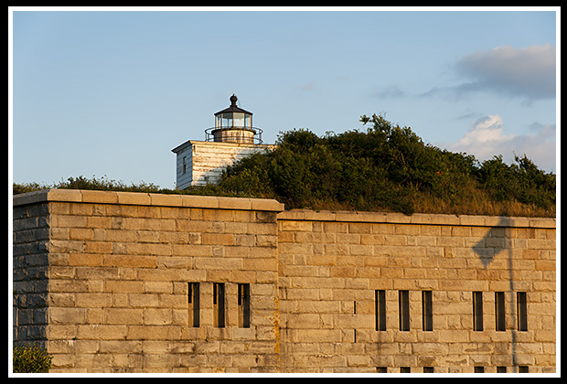
Clark's Point (Fort Taber) Lighthouse
(Heading Eastward)
Borden Flats Light, Fall River, Massachusetts
Take Exit 5 off Route 95 to Route 138 (Broadway) to Bradford, then right at Almond Street to Borden Light Marina.
Clark’s Point Light, New Bedford, Massachusetts
Take Exit 15 off Route 95, then Route 18 South onto Water Street to Fort Taber Park.
Butler Flats Light, New Bedford, Massachusetts
Take Exit 15 off Route 95, then Route 18 South onto Water Street to Fort Taber Park.
Palmer Island Light, New Bedford, Massachusetts
Take Exit 15 off Route 95, then Route 18 South onto Cover Street, left at Morton Court, right at Guilford Street. Park behind industrial buildings, and watch your car and belongings. Can see from parking lot or walk along breakwater.
Ned’s Point Light, Mattapoisett, Massachusetts
Take Exit 19 off Route 95 along North Street. Follow into Mattapoisett Street. Take left on Water Street to Beacon Street, right to Ned’s Point Road to Veteran’s Memorial Park.
Directions to These
Cape Cod Lighthouses
Long Point Lighthouse
(Heading Around the Cape)
Wing’s Neck Light, Pocasset, Massachusetts
Follow Route 6 to Borne Rotary to Route 28 South into Pocasset. Turn right onto Barlows Landing, cross Shore Street, then right on Wing’s Neck Street to end.
Nobska Light, Falmouth, Massachusetts
From Route 28 in Falmouth, follow Shore Road, then right on Surf Drive to Beach Street onto Oyster Pond Street, then left on Nobska Road to light.
Lewis Bay Light, and South Hyannis Harbor (Rear Range) Light, Hyannis, Massachusetts
To view the privately built Hyannis Harbor Light (Lewis Bay Light), take Route 6 to Route 132 into Hyannis. At cross of Routes 132 and 28, go south on Hyannis-Barnstable, south on Ocean Street, left on South Street, right on Pleasant Street to the end. Great views by the wharf. The lighthouse is at the end of Channel Point Road and public access is not allowed.
To view the Hyannis Harbor Rear Range Light (the original Hyannis Harbor Light station). Take Sea Street to the end where you can park at Keyes Beach and get a view of the lighthouse from the beach, heading east. The lighthouse is at the end of Harbor Road and public access is not allowed.
Bass River Light, West Dennis, Massachusetts
Take Route 28, south on School Street to Lighthouse Road to the inn.
Stage Harbor Light, Chatham. Massachusetts
Take Route 6 to Route 137 to Chatham. Left on Old Queen Road to Route 28, right on Barn Hill Street, right on Harding’s Beach. It’s a one-mile hike over soft sand from parking lot.
Chatham Light, Chatham, Massachusetts
Take Route 6 to Route 137 to Chatham. Take left on Old Queen Road to Route 28 and follow Main Street to the light.
Nauset Light, Eastham, Massachusetts
Take Route 6 to Eastham to right on Bracket Street, left on Nauset Street, right on Cable Street, left on Ocean View Drive to light.
Three Sisters Lights, Eastham, Massachusetts
Take Route 6 to Eastham, then right on Bracket Street, left on Nauset Street, right on Cable Street, left on Ocean View Drive to Nauset Light. The other lighthouses are a 1/3-mile walk after Nauset Light.
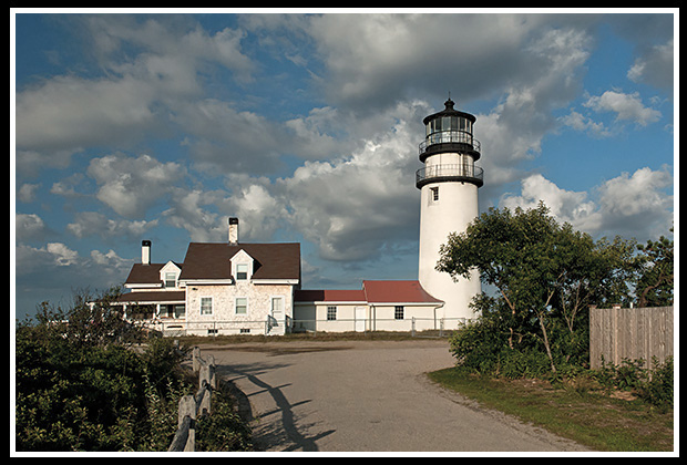
Cape Cod (Highland) Lighthouse
Cape Cod (Highland) Light, Truro, Massachusetts
Take Route 6 through Truro to Cape Cod Light\Highland exit, take South Highland Road, then left on Lighthouse Road.
Race Point Light, Provincetown, Massachusetts
Take Route 6 towards Provincetown, take Race Point Road until it ends at the beach. It’s a two-mile hike in soft sand to the light, or you can get a permit to drive a 4-wheel drive vehicle. Art’s Dune Tours offers trips to Race Point Light.
Wood End Light, Provincetown, Massachusetts
Take Route 6 into Provincetown, then left onto Commercial (Route 6A) Street and park at breakwater. It’s a mile walk along the breakwater to the light.
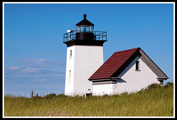
Long Point Light, Provincetown, Massachusetts
Take Route 6 into Provincetown, then left onto Commercial (Route 6A) Street and park at breakwater. It’s a mile walk along the breakwater, then another ¾ in soft sand during low tide to the lighthouse. Be careful, watch the tide! Flyer’s Boat Yard offers a shuttle service to the light.
Martha’s Vineyard and Nantucket Island Lighthouses, MA
Note: Although you have to take a ferry to the islands, you can drive, hike, or bike to any of the lighthouses.
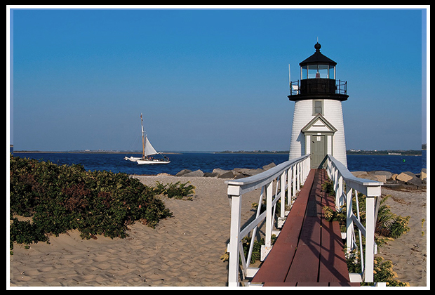
Brant Point Lighthouse
Ferries to the Islands
You can take various ferries to Nantucket and Martha’s Vineyard. Here are the main ones so you can schedule your trip to these great vacation destinations.
- Island Queen leaves from Falmouth
- Hy-Line Cruises from Hyannis
- Martha's Vineyard Fast Ferry from Massachusetts and Rhode Island
- Steamship Authority from various Massachusetts ports.
Martha’s Vineyard Island Lighthouses
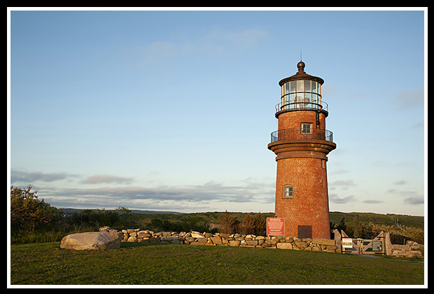
Gay Head (Aquinnah) Lighthouse
Gay Head Light, Aquinnah, Martha’s Vineyard, Massachusetts
Follow signs to Chilmark, west on South Street to light.
West Chop Light, Tisbury, Martha’s Vineyard, Massachusetts
West on Union Street, then right on Main Street to West Chop Street.
East Chop Light, Oak Bluffs, Martha’s Vineyard, Massachusetts
Take East Chop Street north to Highland Drive.
Edgartown Light, Edgartown, Martha’s Vineyard, Massachusetts
Take Main Street into Edgartown, left on Water Street to light.
Cape Poge Light, Chappaquiddick Island, Martha’s Vineyard, MA
Take the short Edgartown- Chappaquiddick Ferry, to Chappaquiddick for 2 ½ miles. Take right on Dike Street (dirt road) to Dike Bridge to Cape Poge gatehouse. Tour of lighthouse and refuge provided by Cape Poge Trustees of Reservations.
Nantucket Island Lighthouses
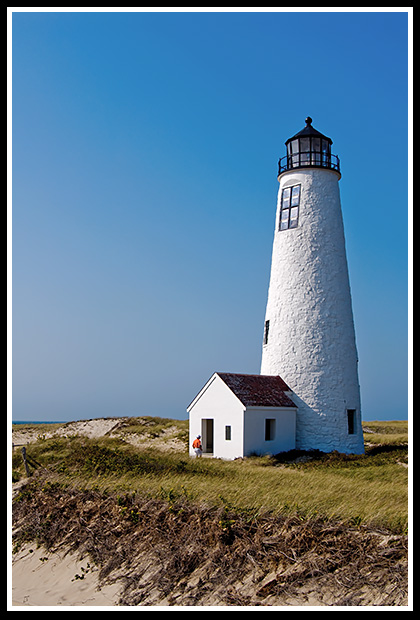
Great Point Lighthouse
Brant Point Light, Nantucket, Massachusetts
From the wharf, go up Broad Street, then right on South Beach Street, right on Easton Street to light.
Sankaty Head Light, Siasconset, Massachusetts
From the wharf, go up Broad Street, then left on South Water Street, right on Main Street, left on Orange Street to rotary. Take Milestone Street for 6 miles to town, then left on Shell Street into Sankaty, right on Barberry Lane, left on Baxter Street to the light.
Great Point Light, Nantucket, Massachusetts
To reach the Coskata-Coatue Wildlife Refuge where the light is located, go up Broad Street to South Water, then right on Main Street. Take left on Orange Street to rotary onto Milestone Street, then left on Polpis Street for 4 ½ miles, left on Wauwinet Street for 2 1/2 miles to the Refuge.
Drive or Hike to These
Boston Region and
North Shore Lighthouses
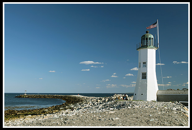
Scituate Lighthouse
(Heading Northeast )
Scituate Light, Scituate, Massachusetts
Take Route 3 North, to Route 53, to Route 123 North (Country Way). Take right at Stockbridge Street, then right at First Parish, left at Front Street, right at Jericho Street, then right at Lighthouse Road.
Marblehead Light, Marblehead, Massachusetts
Take Route 1A North from Route 95, to Route 129, to end. Take right at Beach Street until intersects with Ocean Ave., then bare left on Harbor Road onto Marblehead Neck. Follow Ocean Avenue, then left at Follett Street, to Chandler Hover Park at the light.
Derby Wharf Light, Salem, Massachusetts
Take Route 95, to Route 62 in Danvers to Salem. Take Highway 1A to Derby Street, follow waterfront signs. Light is at end of wharf.
Fort Pickering Light, Salem, Massachusetts
Take Route 1A in Salem, right on Derby Street, then right on Winter Island Road to Winter Island Park.
Hospital Point Light, Beverly, Massachusetts
(private residence)
From Route 95 follow Route 128 to Exit 18 onto Old Essex Road to Route 22. Take East Corning Street, then Bayview Street to Lynch Park, to view the lighthouse.
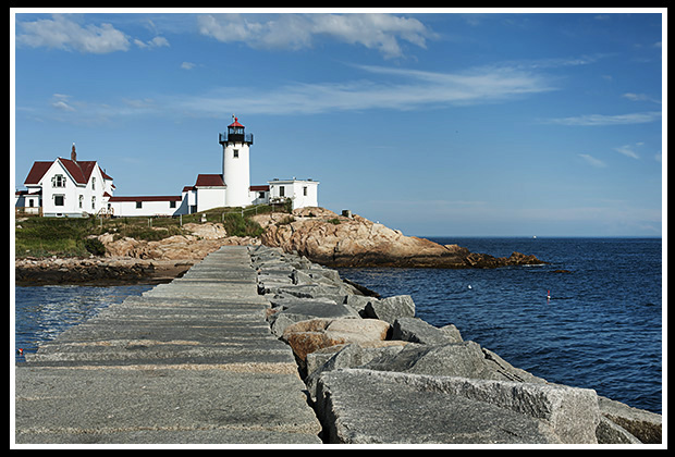
Eastern Point Lighthouse
Eastern Point Light, Gloucester, Massachusetts
Take Route 95 to Route 128. At junction of Routes 128 and 127, take right on East Main Street, to Eastern Point Road and follow along harbor. Bear right along harbor a few miles, then pass small private beach and go through “Private Road” sign. Go straight through yacht club sign to the end to the light.
Annisquam Light, Annisquam, Massachusetts
From Route 95 follow Route 128 towards Gloucester. At the rotary junction of Routes 127 and 128, go on Route 127 three miles to Washington Street, the left on Bridgewater Street, then left on Leonard Street by church. Turn right onto Norwood Heights (sign). Bear right at fork, cross Ocean Ave, turn right at “T”, then left on Wigwam Street to Lighthouse Road. There's a small private beach to quickly observe the lighthouse, may need to ask permission.
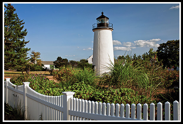
Plum Island Light, Newburyport, Massachusetts
Take Route 95, to Route 113 and then follow into Newburyport. Follow to Plum Island sign, right at light to the end; take another right, and a left over bridge onto Plum Island. Turn left on Northern Boulevard to the light.
Newburyport Harbor Range Lights, Newburyport, Massachusetts
From Route 95 North, take Exit 57 to Storey Ave. Take right on High Street, left on Summer Street to Merrimac Street which turns into Water Street. Right on Water Street left to range light, other light can seen on outside Coast Guard grounds.
Newburyport Harbor
Plum Island Lighthouse
Books to Explore
 Available in paperback. |
New England's Haunted Lighthouses: Explore the historical mysteries surrounding the haunted lighthouses of New England! Uncover ghostly tales of lingering keepers, victims of misfortune or from local shipwrecks, lost souls, ghost ships, and more. Immerse yourself in the tales associated with these iconic beacons! |
Lighthouses and Coastal Attractions of Southern New England: This book provides special human interest stories from each of the 92 lighthouses of the southern coastline, along with plenty of indoor and outdoor coastal attractions and tours you can explore. Enjoy your passion! Look inside! |
|
Available in paperback, hardcover, and as an eBook for all devices.
|
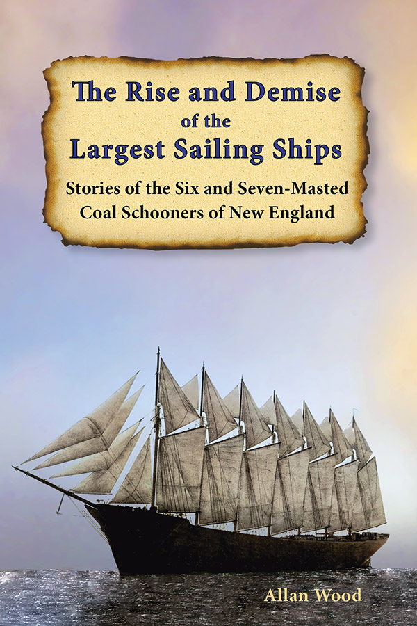
The Rise and Demise of the Largest Sailing Ships: In the early 1900s, New England shipbuilders constructed the world’s largest sailing ships amid social and political reforms. These giants of sail were the ten original six-masted coal schooners and one colossal seven-masted vessel, built to carry massive quantities of coal and building supplies, and measured longer than a football field! This self-published book, balanced with plenty of color and vintage images, showcases the historical accounts that followed these mighty ships. These true stories include competitions, accidents, battling destructive storms, acts of heroism, and their final voyages. |